Community Development


Housing Authority of Yamhill County, on behalf of property owner Burch Feero, Inc., is requesting approval of a Planned Development Amendment to amend the conditions of
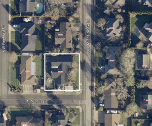
The applicant is requesting approval of a zoning variance for the property at 2005 NW Michelbook Lane (Tax Lot R4417BD00800).
Applicant: Andrew and Susanne Duvall
Denny Elmer with C.S. Property Holdings is requesting approval of the design of a proposed exterior alteration to the Third Street façade of an existing commercial building. The applicant is proposing to
TDJC, LLC is requesting approval of a conditional use permit to allow for the construction of a social relief facility for Yamhill County Health & Human Services.
